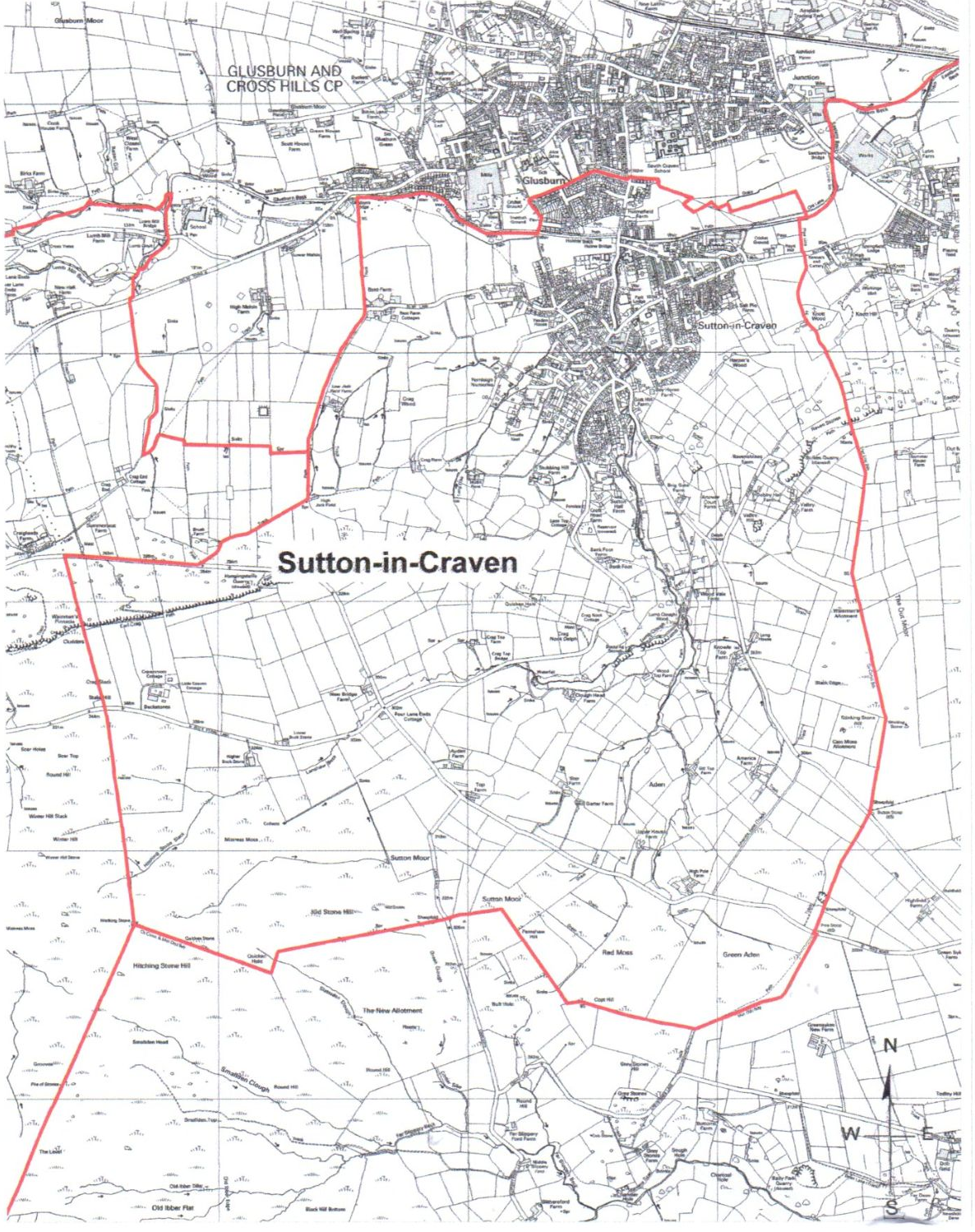
Parish Boundary
Craven District Council (“the council”), in accordance with section 82 of the Local Government and Public Involvement in Health Act 2007 (“the 2007 Act”) made some changes to boundaries in 2011 with effect from 2012.
This was done in accordance with section 93 of the 2007 Act, has consulted with the local government electors and other interested persons and has had regard to the need to secure that community governance reflects the identities and interests of the community and is effective and convenient:
Sutton-in-Craven’s Parish Boundary changed with effect from 2012.
Sutton-in-Craven, and Glusburn and Cross Hills, and Cowling New Boundary –
At a point to the west of Glusburn Bridge and south-east of 1-5 Holme Ghyll where the current Glusburn and Cross Hills, and Sutton-in-Craven parish boundary runs along the southern end of Glusburn Beck, continue the boundary west along the southern edge of the Beck to a point just east of Bridge End Cottage. At the point in line with the track shown on the Ordnance Survey map (OS) that leads to Jack Field Lane to the south, follow the western edge of that track in a southerly direction, continuing past the first cattle grid up to the point where Bent Farm is directly to the east. Then continue in a south-south-easterly direction along the field boundaries adjoining the western edge of the track that runs adjacent to Jack Field Lane, until Low Jack Field Farm to the east is reached.
At Low Jack Field Farm continue in a southerly direction along the western boundary of the field to the west of the track and Low Jack Field Farm. At that point where the track meets the southern boundary of the field immediately south-west of Low Jack Field Farm, take that field boundary in a westerly direction to where it meets the boundary of the next field to the west. Then follow that field boundary in a northerly direction, for a short distance, to the point where that boundary meets the northern boundary of the same field to the west. Go west along that field’s northern boundary and continue, in a straight line, along the boundary of the next two adjoining fields to the south. Where the northern boundary of that second field to the south meets the path shown on the Ordnance Survey map (OS), take the line of the path in a northerly direction, for a short distance, to the point where it meets the southern boundary of the field to the west. Follow the southern boundary of that field in a westerly direction to the western boundary with the next field. Then follow that field boundary in a southerly and south-south-westerly direction until it meets the eastern boundary of the lane. Then take the eastern boundary of the lane in a northerly direction along its full length to its junction with the A6068 Colne Road.
Cross to the northern side of the A6068 road and head in an east-north-easterly direction, for a short distance, to the point where the road meets the first field boundary to the northern edge of the road. Follow that field boundary in a northerly direction to the centre of Leys Beck and then follow the centre line of Leys Beck in a north-north-easterly direction until it joins up with the current Cowling and Sutton-in-Craven boundary that will become the Cowling, and Glusburn and Cross Hills parish boundary. The current boundary then continues in north-north-easterly direction towards Lumb Mill Bridge.
Sutton-in-Craven and Cowling New Boundary –
To the south of Low Jack Field Farm, at the point where the new Sutton / Glusburn and Cross Hills boundary takes a westerly heading, the new Cowling boundary with Sutton-in-Craven continues in a southerly direction along the track that is an extension of Jack Field Lane. Continue to follow the western boundary of that track to where it meets High Jack Field Farm to the east. Then continue along the north-western edge of the track in south-westerly direction, past Bush Farm to the west, until the track meets Dick Lane. At Dick Lane, head west along the northern edge of the unclassified road to meet the line of the current boundary between Cowling and Sutton-in-Craven to the south of Swallow Cottage.
The land and property:
(i) In the Malsis / Glusburn bridge area to the north and east of the new boundary between Cowling, and Glusburn and Cross Hills is
transferred to Glusburn and Cross Hills Parish from Sutton-in-Craven Parish:
(ii) To the west and south of the new boundary between Cowling, and Glusburn and Cross Hills, and Cowling and Sutton-in-Craven is
transferred to Cowling Parish from Sutton-in-Craven Parish; and
(iii) In the Glusburn Bridge area, to the south of the new boundary along Glusburn Beck and east of the new boundary along Jack Field Lane,
between the Glusburn and Cross Hills, and Sutton-in-Craven new boundary, is transferred to Sutton-in-Craven Parish from Glusburn and
Cross Hills Parish.
Glusburn and Cross Hills / Sutton-in-Craven New Boundary –
To the south of 4/6 Walker Close, the boundary between Glusburn and Cross Hills, and Sutton-in-Craven Parishes runs alongside the southern edge of Holme Beck. The new boundary will, from that point, run along side the southern edge of the Beck to the point where it reaches the footbridge across the Beck just to the west of the southern boundary of 57 The Hawthorns and south of the football ground. From that point, the new boundary will go north along the western side of the footbridge and then along the western side of the footpath adjoining the football ground, along the eastern side of the Pavilion, to the southern boundary with the property known as The Barn a the southern end of Sutton Fields. At this point, take the boundary west and then north along the western boundary of the Sutton Fields properties, adjacent to the football ground, until it reaches the existing Glusburn and Cross Hills and Sutton-in-Craven parish boundary. The land and property to the north and west of the new boundary is transferred to Glusburn and Cross Hills Parish from Sutton-in-Craven Parish.
Properties Transferred from Sutton-in-Craven to Glusburn and Cross Hills –
West End House, Malsis School, Malsis, BD20 8DT
Low Barn, Malsis, BD20 8DT
Coachman’s Barn, Malsis BD20 8DT
Stable Cottage, Malsis, BD20 8DT
Pepperpot House, Malsis BD20 8DT
The Lodge, Malsis school, BD20 8DT
The Mistal, Malsis BD20 8DS
The Dog and Gun Inn, Malsis BD20 8DT
Malsis School, Malsis BD20 8DT
1,2,3,4,5,6,8 High Malsis BD20 8DU
High Malsis Farm House, High Malsis BD20 8DU
High Malsis Farm Cottage, High Malsis BD20 8DU
Properties Transferred from Sutton-in-Craven to Cowling -
Crag End Farm Cottage, Cowling BD22 0JU
The Farlings, Crag End Farm, Cowling BD22 0JU
Crag End Farm, Cowling BD22 0JU
1,2,3,4,5,6,7,8 New Hall Farm, Cowling BD22 0JQ
New Hall Farm House, Cowling BD22 0JQ
Lower Land Ends Cottage, Cowling BD22 0JU
Lower Land Ends Farm, Cowling BD22 0JU
The Bungalow, Land Ends Far, Cowling BD22 0JU
Brush Farm, Sutton-in-Craven BD20 7EJ
Summerseat Farm, Cowling BD22 0JU